|
| at: |
Bankhead National Forest |
Data from USFS GIS
 show on map
 animate
Trail users:


Elevation Profile
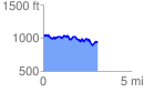
 3.072476 mi
 412.93 ft
 482.85 ft
 -69.92 ft
 2.98 %
GPX Downloads: Track Route
![]()
|
| at: |
Bankhead National Forest |
show on map
animate
3.072476 mi
412.93 ft
482.85 ft
-69.92 ft
2.98 %