|
| at: |
Bankhead National Forest |
Data from USFS GIS
 show on map
 animate
Trail users:


Elevation Profile
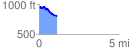
 1.126235 mi
 78.59 ft
 238.23 ft
 -159.63 ft
 4.01 %
GPX Downloads: Track Route
![]()
|
| at: |
Bankhead National Forest |
show on map
animate
1.126235 mi
78.59 ft
238.23 ft
-159.63 ft
4.01 %