|
| at: |
Bankhead National Forest |
Data from USFS GIS
 show on map
 animate
Trail users:


Elevation Profile
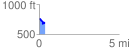
 0.358998 mi
 40.69 ft
 103.32 ft
 -62.64 ft
 5.45 %
GPX Downloads: Track Route
![]()
|
| at: |
Bankhead National Forest |
show on map
animate
0.358998 mi
40.69 ft
103.32 ft
-62.64 ft
5.45 %