|
| at: |
Bankhead National Forest |
Data from USFS GIS
 show on map
 animate
Trail users:


Elevation Profile
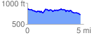
 4.750191 mi
 475.86 ft
 575.04 ft
 -99.18 ft
 2.29 %
GPX Downloads: Track Route
![]()
|
| at: |
Bankhead National Forest |
show on map
animate
4.750191 mi
475.86 ft
575.04 ft
-99.18 ft
2.29 %