|
| at: |
Bankhead National Forest |
Data from USFS GIS
 show on map
 animate
Trail users:


Elevation Profile
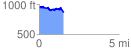
 1.576058 mi
 155.37 ft
 247.72 ft
 -92.35 ft
 2.98 %
GPX Downloads: Track Route
![]()
|
| at: |
Bankhead National Forest |
show on map
animate
1.576058 mi
155.37 ft
247.72 ft
-92.35 ft
2.98 %