|
| at: |
Bankhead National Forest |
Data from USFS GIS
 show on map
 animate
Trail users:


Elevation Profile
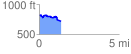
 1.393410 mi
 74.54 ft
 168.27 ft
 -93.73 ft
 2.29 %
GPX Downloads: Track Route
![]()
|
| at: |
Bankhead National Forest |
show on map
animate
1.393410 mi
74.54 ft
168.27 ft
-93.73 ft
2.29 %