|
| at: |
Bankhead National Forest |
Data from USFS GIS
 show on map
 animate
Trail users:


Elevation Profile
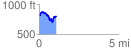
 1.091916 mi
 233.98 ft
 254.86 ft
 -20.89 ft
 4.42 %
GPX Downloads: Track Route
![]()
|
| at: |
Bankhead National Forest |
show on map
animate
1.091916 mi
233.98 ft
254.86 ft
-20.89 ft
4.42 %