|
| at: |
Bankhead National Forest |
Data from USFS GIS
 show on map
 animate
Trail users:


Elevation Profile
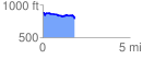
 1.827753 mi
 93.64 ft
 193.41 ft
 -99.76 ft
 2.00 %
GPX Downloads: Track Route
![]()
|
| at: |
Bankhead National Forest |
show on map
animate
1.827753 mi
93.64 ft
193.41 ft
-99.76 ft
2.00 %