|
| at: |
Bankhead National Forest |
Data from USFS GIS
 show on map
 animate
Trail users:


Elevation Profile
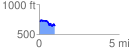
 0.974414 mi
 111.57 ft
 179.13 ft
 -67.57 ft
 3.48 %
GPX Downloads: Track Route
![]()
|
| at: |
Bankhead National Forest |
show on map
animate
0.974414 mi
111.57 ft
179.13 ft
-67.57 ft
3.48 %