|
| at: |
Bankhead National Forest |
Data from USFS GIS
 show on map
 animate
Trail users:


Elevation Profile
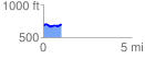
 1.012313 mi
 85.85 ft
 63.88 ft
 21.96 ft
 1.61 %
GPX Downloads: Track Route
![]()
|
| at: |
Bankhead National Forest |
show on map
animate
1.012313 mi
85.85 ft
63.88 ft
21.96 ft
1.61 %