|
| at: |
Bankhead National Forest |
Data from USFS GIS
 show on map
 animate
Trail users:


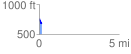
Elevation Profile
 0.192514 mi
 8.99 ft
 79.02 ft
 -70.03 ft
 7.77 %
GPX Downloads: Track Route
![]()
|
| at: |
Bankhead National Forest |
show on map
animate
0.192514 mi
8.99 ft
79.02 ft
-70.03 ft
7.77 %