|
| at: |
Bankhead National Forest |
Data from USFS GIS
 show on map
 animate
Trail users:


Elevation Profile
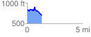
 1.326143 mi
 175.59 ft
 291.66 ft
 -116.06 ft
 4.17 %
GPX Downloads: Track Route
![]()
|
| at: |
Bankhead National Forest |
show on map
animate
1.326143 mi
175.59 ft
291.66 ft
-116.06 ft
4.17 %