|
| at: |
Bankhead National Forest |
Data from USFS GIS
 show on map
 animate
Trail users:


Elevation Profile
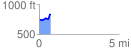
 0.732070 mi
 124.69 ft
 31.13 ft
 93.56 ft
 3.23 %
GPX Downloads: Track Route
![]()
|
| at: |
Bankhead National Forest |
show on map
animate
0.732070 mi
124.69 ft
31.13 ft
93.56 ft
3.23 %