|
| at: |
Bankhead National Forest |
Data from USFS GIS
 show on map
 animate
Trail users:


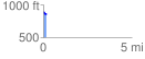
Elevation Profile
 0.180029 mi
 5.84 ft
 41.08 ft
 -35.25 ft
 4.32 %
GPX Downloads: Track Route
![]()
|
| at: |
Bankhead National Forest |
show on map
animate
0.180029 mi
5.84 ft
41.08 ft
-35.25 ft
4.32 %