|
| at: |
Bankhead National Forest |
Data from USFS GIS
 show on map
 animate
Trail users:


Elevation Profile
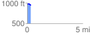
 0.346864 mi
 21.78 ft
 44.86 ft
 -23.08 ft
 2.45 %
GPX Downloads: Track Route
![]()
|
| at: |
Bankhead National Forest |
show on map
animate
0.346864 mi
21.78 ft
44.86 ft
-23.08 ft
2.45 %