|
| at: |
Bankhead National Forest |
Data from USFS GIS
 show on map
 animate
Trail users:


Elevation Profile
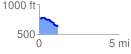
 1.162836 mi
 39.30 ft
 179.83 ft
 -140.53 ft
 2.93 %
GPX Downloads: Track Route
![]()
|
| at: |
Bankhead National Forest |
show on map
animate
1.162836 mi
39.30 ft
179.83 ft
-140.53 ft
2.93 %