|
| at: |
Bankhead National Forest |
Data from USFS GIS
 show on map
 animate
Trail users:


Elevation Profile
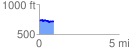
 0.905707 mi
 63.71 ft
 83.45 ft
 -19.74 ft
 1.75 %
GPX Downloads: Track Route
![]()
|
| at: |
Bankhead National Forest |
show on map
animate
0.905707 mi
63.71 ft
83.45 ft
-19.74 ft
1.75 %