|
| at: |
Bankhead National Forest |
Data from USFS GIS
 show on map
 animate
Trail users:


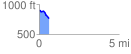
Elevation Profile
 0.601181 mi
 19.27 ft
 150.51 ft
 -131.24 ft
 4.74 %
GPX Downloads: Track Route
![]()
|
| at: |
Bankhead National Forest |
show on map
animate
0.601181 mi
19.27 ft
150.51 ft
-131.24 ft
4.74 %