|
| at: |
Bankhead National Forest |
Data from USFS GIS
 show on map
 animate
Trail users:


Elevation Profile
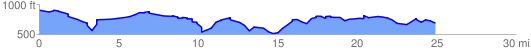
 25.267025 mi
 2170.69 ft
 2465.62 ft
 -294.93 ft
 1.85 %
GPX Downloads: Track Route
![]()
|
| at: |
Bankhead National Forest |
show on map
animate
25.267025 mi
2170.69 ft
2465.62 ft
-294.93 ft
1.85 %