|
| at: |
Talladega National Forest |
Data from USFS GIS
 show on map
 animate
Trail users:


Elevation Profile
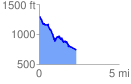
 2.361669 mi
 183.82 ft
 741.83 ft
 -558.01 ft
 5.95 %
GPX Downloads: Track Route
![]()
|
| at: |
Talladega National Forest |
show on map
animate
2.361669 mi
183.82 ft
741.83 ft
-558.01 ft
5.95 %