|
| at: |
Talladega National Forest |
Data from USFS GIS
 show on map
 animate
Trail users:


Elevation Profile
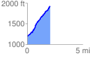
 2.065398 mi
 779.23 ft
 69.64 ft
 709.59 ft
 7.15 %
GPX Downloads: Track Route
![]()
|
| at: |
Talladega National Forest |
show on map
animate
2.065398 mi
779.23 ft
69.64 ft
709.59 ft
7.15 %