|
| at: |
Talladega National Forest |
Data from USFS GIS
 show on map
 animate
Trail users:


Elevation Profile
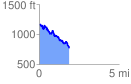
 1.883418 mi
 325.36 ft
 712.41 ft
 -387.05 ft
 7.16 %
GPX Downloads: Track Route
![]()
|
| at: |
Talladega National Forest |
show on map
animate
1.883418 mi
325.36 ft
712.41 ft
-387.05 ft
7.16 %