|
| at: |
Talladega National Forest |
Data from USFS GIS
 show on map
 animate
Trail users:


Elevation Profile
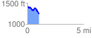
 1.018354 mi
 135.67 ft
 307.31 ft
 -171.64 ft
 5.72 %
GPX Downloads: Track Route
![]()
|
| at: |
Talladega National Forest |
show on map
animate
1.018354 mi
135.67 ft
307.31 ft
-171.64 ft
5.72 %