|
| at: |
Talladega National Forest |
Data from USFS GIS
 show on map
 animate
Trail users:


Elevation Profile
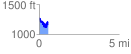
 0.562683 mi
 213.91 ft
 292.37 ft
 -78.46 ft
 9.84 %
GPX Downloads: Track Route
![]()
|
| at: |
Talladega National Forest |
show on map
animate
0.562683 mi
213.91 ft
292.37 ft
-78.46 ft
9.84 %