|
| at: |
Talladega National Forest |
Data from USFS GIS
 show on map
 animate
Trail users:


Elevation Profile
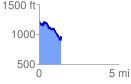
 1.397126 mi
 245.25 ft
 571.40 ft
 -326.15 ft
 7.75 %
GPX Downloads: Track Route
![]()
|
| at: |
Talladega National Forest |
show on map
animate
1.397126 mi
245.25 ft
571.40 ft
-326.15 ft
7.75 %