|
| at: |
Talladega National Forest |
Data from USFS GIS
 show on map
 animate
Trail users:


Elevation Profile
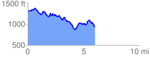
 6.052105 mi
 955.47 ft
 1330.29 ft
 -374.82 ft
 4.16 %
GPX Downloads: Track Route
![]()
|
| at: |
Talladega National Forest |
show on map
animate
6.052105 mi
955.47 ft
1330.29 ft
-374.82 ft
4.16 %