|
| at: |
Blue Ridge WMA Bull/Jake Mountain |
Data from David Muse
 show on map
 animate
Trail users:


Elevation Profile
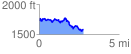
 2.771337 mi
 520.88 ft
 658.89 ft
 -138.01 ft
 4.50 %
GPX Downloads: Track Route
![]()
|
| at: |
Blue Ridge WMA Bull/Jake Mountain |
show on map
animate
2.771337 mi
520.88 ft
658.89 ft
-138.01 ft
4.50 %