|
| at: |
Talladega National Forest |
Data from USFS GIS
 show on map
 animate
Trail users:


Elevation Profile
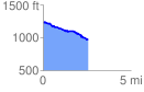
 2.634608 mi
 186.17 ft
 416.54 ft
 -230.37 ft
 2.99 %
GPX Downloads: Track Route
![]()
|
| at: |
Talladega National Forest |
show on map
animate
2.634608 mi
186.17 ft
416.54 ft
-230.37 ft
2.99 %