|
| at: |
Talladega National Forest |
Data from USFS GIS
 show on map
 animate
Trail users:


Elevation Profile
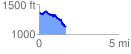
 1.678598 mi
 217.03 ft
 448.21 ft
 -231.18 ft
 5.06 %
GPX Downloads: Track Route
![]()
|
| at: |
Talladega National Forest |
show on map
animate
1.678598 mi
217.03 ft
448.21 ft
-231.18 ft
5.06 %