|
| at: |
Talladega National Forest |
Data from USFS GIS
 show on map
 animate
Trail users:


Elevation Profile
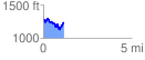
 1.176320 mi
 243.56 ft
 295.58 ft
 -52.02 ft
 4.76 %
GPX Downloads: Track Route
![]()
|
| at: |
Talladega National Forest |
show on map
animate
1.176320 mi
243.56 ft
295.58 ft
-52.02 ft
4.76 %