|
| at: |
Talladega National Forest |
Data from USFS GIS
 show on map
 animate
Trail users:


Elevation Profile
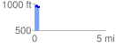
 0.318310 mi
 59.13 ft
 77.81 ft
 -18.68 ft
 4.63 %
GPX Downloads: Track Route
![]()
|
| at: |
Talladega National Forest |
show on map
animate
0.318310 mi
59.13 ft
77.81 ft
-18.68 ft
4.63 %