|
| at: |
Talladega National Forest |
Data from USFS GIS
 show on map
 animate
Trail users:


Elevation Profile
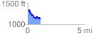
 1.143219 mi
 134.54 ft
 333.32 ft
 -198.78 ft
 5.52 %
GPX Downloads: Track Route
![]()
|
| at: |
Talladega National Forest |
show on map
animate
1.143219 mi
134.54 ft
333.32 ft
-198.78 ft
5.52 %