|
| at: |
Blue Ridge WMA |
Data from David Muse
 show on map
 animate
Trail users:


Elevation Profile
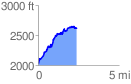
 2.372264 mi
 836.27 ft
 253.76 ft
 582.50 ft
 6.68 %
GPX Downloads: Track Route
![]()
|
| at: |
Blue Ridge WMA |
show on map
animate
2.372264 mi
836.27 ft
253.76 ft
582.50 ft
6.68 %