|
| at: |
Talladega National Forest |
Data from USFS GIS
 show on map
 animate
Trail users:


Elevation Profile
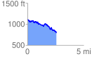
 2.610497 mi
 454.01 ft
 778.79 ft
 -324.78 ft
 5.65 %
GPX Downloads: Track Route
![]()
|
| at: |
Talladega National Forest |
show on map
animate
2.610497 mi
454.01 ft
778.79 ft
-324.78 ft
5.65 %