|
| at: |
Blue Ridge WMA |
Data from USFS GIS
 show on map
 animate
Trail users:


Elevation Profile
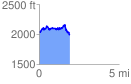
 1.918488 mi
 361.95 ft
 403.44 ft
 -41.50 ft
 3.98 %
GPX Downloads: Track Route
![]()
|
| at: |
Blue Ridge WMA |
show on map
animate
1.918488 mi
361.95 ft
403.44 ft
-41.50 ft
3.98 %