|
| at: |
Talladega National Forest |
Data from USFS GIS
 show on map
 animate
Trail users:


Elevation Profile
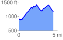
 4.546704 mi
 1704.12 ft
 1465.81 ft
 238.31 ft
 7.10 %
GPX Downloads: Track Route
![]()
|
| at: |
Talladega National Forest |
show on map
animate
4.546704 mi
1704.12 ft
1465.81 ft
238.31 ft
7.10 %