|
| at: |
Talladega National Forest |
Data from USFS GIS
 show on map
 animate
Trail users:


Elevation Profile
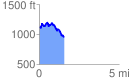
 1.557764 mi
 287.51 ft
 430.72 ft
 -143.21 ft
 5.24 %
GPX Downloads: Track Route
![]()
|
| at: |
Talladega National Forest |
show on map
animate
1.557764 mi
287.51 ft
430.72 ft
-143.21 ft
5.24 %