|
| at: |
Talladega National Forest |
Data from USFS GIS
 show on map
 animate
Trail users:


Elevation Profile
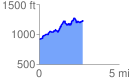
 2.767881 mi
 720.42 ft
 381.59 ft
 338.82 ft
 4.93 %
GPX Downloads: Track Route
![]()
|
| at: |
Talladega National Forest |
show on map
animate
2.767881 mi
720.42 ft
381.59 ft
338.82 ft
4.93 %