|
| at: |
Talladega National Forest |
Data from USFS GIS
 show on map
 animate
Trail users:


Elevation Profile
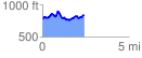
 2.419520 mi
 429.74 ft
 370.98 ft
 58.76 ft
 3.36 %
GPX Downloads: Track Route
![]()
|
| at: |
Talladega National Forest |
show on map
animate
2.419520 mi
429.74 ft
370.98 ft
58.76 ft
3.36 %