|
| at: |
Talladega National Forest |
Data from USFS GIS
 show on map
 animate
Trail users:


Elevation Profile
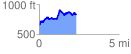
 2.342280 mi
 603.31 ft
 427.97 ft
 175.34 ft
 4.88 %
GPX Downloads: Track Route
![]()
|
| at: |
Talladega National Forest |
show on map
animate
2.342280 mi
603.31 ft
427.97 ft
175.34 ft
4.88 %