|
| at: |
Talladega National Forest |
Data from USFS GIS
 show on map
 animate
Trail users:


Elevation Profile
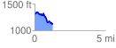
 1.271036 mi
 156.80 ft
 341.96 ft
 -185.16 ft
 5.10 %
GPX Downloads: Track Route
![]()
|
| at: |
Talladega National Forest |
show on map
animate
1.271036 mi
156.80 ft
341.96 ft
-185.16 ft
5.10 %