| at: |
Blue Ridge WMA Bull/Jake Mountain |
Data from David Muse
 show on map
 animate
Trail users:


Elevation Profile
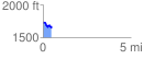
 0.488687 mi
 64.38 ft
 147.36 ft
 -82.99 ft
 5.71 %
GPX Downloads: Track Route
![]()
| at: |
Blue Ridge WMA Bull/Jake Mountain |
show on map
animate
0.488687 mi
64.38 ft
147.36 ft
-82.99 ft
5.71 %