|
| at: |
Talladega National Forest |
Data from USFS GIS
 show on map
 animate
Trail users:


Elevation Profile
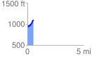
 0.520824 mi
 194.85 ft
 26.35 ft
 168.50 ft
 7.09 %
GPX Downloads: Track Route
![]()
|
| at: |
Talladega National Forest |
show on map
animate
0.520824 mi
194.85 ft
26.35 ft
168.50 ft
7.09 %