|
| at: |
Talladega National Forest |
Data from USFS GIS
 show on map
 animate
Trail users:


Elevation Profile
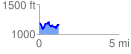
 1.237183 mi
 233.01 ft
 250.53 ft
 -17.51 ft
 3.84 %
GPX Downloads: Track Route
![]()
|
| at: |
Talladega National Forest |
show on map
animate
1.237183 mi
233.01 ft
250.53 ft
-17.51 ft
3.84 %