|
| at: |
Talladega National Forest |
Data from USFS GIS
 show on map
 animate
Trail users:


Elevation Profile
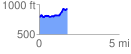
 1.782481 mi
 291.15 ft
 149.40 ft
 141.75 ft
 3.09 %
GPX Downloads: Track Route
![]()
|
| at: |
Talladega National Forest |
show on map
animate
1.782481 mi
291.15 ft
149.40 ft
141.75 ft
3.09 %