|
| at: |
Talladega National Forest |
Data from USFS GIS
 show on map
 animate
Trail users:


Elevation Profile
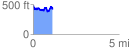
 1.127429 mi
 211.73 ft
 282.93 ft
 -71.19 ft
 4.75 %
GPX Downloads: Track Route
![]()
|
| at: |
Talladega National Forest |
show on map
animate
1.127429 mi
211.73 ft
282.93 ft
-71.19 ft
4.75 %