|
| at: |
Talladega National Forest |
Data from USFS GIS
 show on map
 animate
Trail users:


Elevation Profile
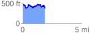
 1.893724 mi
 301.07 ft
 418.40 ft
 -117.33 ft
 4.18 %
GPX Downloads: Track Route
![]()
|
| at: |
Talladega National Forest |
show on map
animate
1.893724 mi
301.07 ft
418.40 ft
-117.33 ft
4.18 %