|
| at: |
Talladega National Forest |
Data from USFS GIS
 show on map
 animate
Trail users:


Elevation Profile
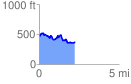
 2.271905 mi
 292.84 ft
 397.61 ft
 -104.77 ft
 3.31 %
GPX Downloads: Track Route
![]()
|
| at: |
Talladega National Forest |
show on map
animate
2.271905 mi
292.84 ft
397.61 ft
-104.77 ft
3.31 %