|
| at: |
Talladega National Forest |
Data from USFS GIS
 show on map
 animate
Trail users:


Elevation Profile
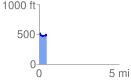
 0.467176 mi
 68.72 ft
 63.20 ft
 5.52 ft
 2.79 %
GPX Downloads: Track Route
![]()
|
| at: |
Talladega National Forest |
show on map
animate
0.467176 mi
68.72 ft
63.20 ft
5.52 ft
2.79 %