|
| at: |
Talladega National Forest |
Data from USFS GIS
 show on map
 animate
Trail users:


Elevation Profile
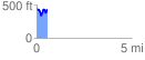
 0.574007 mi
 154.91 ft
 185.43 ft
 -30.51 ft
 6.12 %
GPX Downloads: Track Route
![]()
|
| at: |
Talladega National Forest |
show on map
animate
0.574007 mi
154.91 ft
185.43 ft
-30.51 ft
6.12 %